


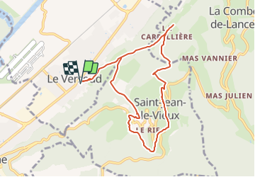
Le VERSOUD - St JEAN-le-VIEUX

d.rochas
User

Length
9.1 km

Max alt
756 m

Uphill gradient
563 m
Km-Effort
16.7 km

Min alt
234 m

Downhill gradient
564 m
Boucle
Yes
Creation date :
2021-11-22 15:48:34.634
Updated on :
2021-11-22 15:55:39.05
3h47
Difficulty : Difficult

FREE GPS app for hiking
 SityTrail
IGN / Geographical institutes
SityTrail Plus
The world is yours!
About
Trail Walking of 9.1 km to be discovered at Auvergne-Rhône-Alpes, Isère, Le Versoud. This trail is proposed by d.rochas.
Description
Boucle
Positioning
Country:
France
Region :
Auvergne-Rhône-Alpes
Department/Province :
Isère
Municipality :
Le Versoud
Location:
Unknown
Start:(Dec)
Start:(UTM)
724733 ; 5010747 (31T) N.
Comments